do geography / zwischenraumkarten
10 maps about the interspace
window view map
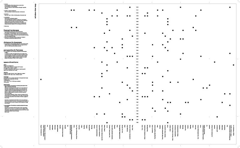
// method: documentation of the window view on a train trip / documentation of the landscape // view from the train in both directions through 2 opposite windows
// location / means of transport: train trip between thusis and sameden / switzerland
// structure: time line / from 11:36 to 12:42 (duration of the train trip)
// visualization: symmetrical coordination system // one coordinate axes visualizes the time line / train track / the other coordinate axes (mirrored) describes the different objects that you see from the window of the train / the distance between points and time line visualizes the distance between objects of the landscape and the train
// linear map
content: framed landscape
// impossibility to capture the whole environment // deformation of the landscape / cut out of the environment
// impossibility to see the target / view to the side instead of in direction of the target / one does not head towards something, but moves along something
// sequence of landscape cutouts / sequence of objects / one object is followed (hunted) by the next
distance & closeness // our perception of the landscape depends on the velocity of the vehicle / because of high velocity close-up range cannot be seen / far field becomes endless panorama
perspective & flatness // our perception of the interspace depends on the direction of sight / in direction of traffic: the objects that seem to appear from nowhere and grow very quickly / the closer you get the easier you can recognise an object, the second you reach it disappears immediately / against direction of traffic: the object appears abruptly, you follow it until it vanishes
<< >>
<< back to overview
<< back